[{"id":172779143304,"handle":"aeronautical-charts","title":"Aeronautical Charts","updated_at":"2024-05-16T20:45:04-04:00","body_html":"","published_at":"2020-03-04T16:23:11-05:00","sort_order":"best-selling","template_suffix":null,"disjunctive":true,"rules":[{"column":"type","relation":"equals","condition":"Aeronautical Charts"}],"published_scope":"web"},{"id":189145677960,"handle":"coupon-eligible","title":"Coupon Eligible","updated_at":"2024-05-19T04:13:19-04:00","body_html":"","published_at":"2020-12-14T21:11:58-05:00","sort_order":"best-selling","template_suffix":"","disjunctive":false,"rules":[{"column":"vendor","relation":"not_equals","condition":"Lightspeed Aviation"}],"published_scope":"global"},{"id":174248099976,"handle":"federal-aviation-administration","title":"Federal Aviation Administration","updated_at":"2024-05-16T20:45:04-04:00","body_html":null,"published_at":"2020-03-11T14:53:57-04:00","sort_order":"best-selling","template_suffix":null,"disjunctive":true,"rules":[{"column":"vendor","relation":"equals","condition":"Federal Aviation Administration"}],"published_scope":"web"},{"id":285856989320,"handle":"new-additions","title":"New Additions","updated_at":"2024-05-19T04:13:19-04:00","body_html":"","published_at":"2024-05-13T22:18:55-04:00","sort_order":"created-desc","template_suffix":"","disjunctive":false,"rules":[{"column":"variant_price","relation":"greater_than","condition":"1"}],"published_scope":"global"}]
["NoImage"]
Skip to content
Home
›
Federal Aviation Administration
›
Helicopter Route Charts
Helicopter Route Charts
Federal Aviation Administration
HELDC
Sale price
$12.20
Regular price
$15.35
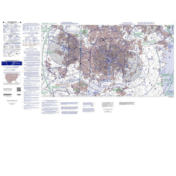
Helicopter Route Charts are three-color charts that depict current aeronautical information useful to helicopter pilots navigating in areas with high concentrations of helicopter activity. Information depicted includes helicopter routes, four classes of heliports with associated frequency and lighting capabilities, NAVAIDS, and obstructions. In addition, pictorial symbols, roads, and easily-identified geographical features are portrayed. The scale is 1:250,000. These charts are updated every 56 days.
choosing a selection results in a full page refresh
Name Your Own Price!
Don’t like the price you see? Make your own offer.
Make an offer